IMPLAN isologo
Drag
Play
IMPLAN
  • Products
    • Product
      • IMPLAN Software
    • By Geography
      • United States
      • Global
      • Canada
    • Capabilities
      • API
      • Data Library
      • Forward Linkages Suite
      • Support Services
  • Why IMPLAN?
    • Why IMPLAN?
      • Economic Impact Analysis
      • Trusted Data Sources
      • Environmental Impacts
      • Job and Employment Impacts
      • Tax Impacts
    • Reporting
      • Step by Step Guides
      • Embeddable Maps
      • Reporting and Insights
  • Solutions
    • By Industry
      • Academic
      • Agriculture
      • Associations
      • Consulting
      • Corporations
      • Economic Development
      • Energy
      • Finance
      • Government
      • Healthcare
      • Manufacturing
      • Real Estate
      • Tourism
    • By Use Case
      • Advocacy
      • Climate Risk Modeling
      • Data Aggregation
      • Economic Footprint
      • Education & Research
      • Environmental (ESG)
      • Grants and Funding
      • Natural Disasters
      • Policy Change
      • Scope 1, 2, 3 Emissions
      • Site Selection
      • Supplier Diversity
      • Tariffs
      • Tax Strategy
      • University Libraries
  • Pricing
  • Resources
    • Resources
      • Blog
      • Case Studies
      • Webinars
      • White Papers
      • E-Books
      • Reports Using IMPLAN
      • IMPLAN Certified Economist Program
      • IMPLAN Press Resources
      • IMPLAN Training
  • About
    • About
      • Careers
      • Company
      • IMPLAN FAQ
      • History
      • Contact Us
  • Log In
  • Support
  • Book a Demo
MenuClose
  • Products
    • Product
      • IMPLAN Software
    • By Geography
      • United States
      • Global
      • Canada
    • Capabilities
      • API
      • Data Library
      • Forward Linkages Suite
      • Support Services
  • Why IMPLAN?
    • Why IMPLAN?
      • Economic Impact Analysis
      • Trusted Data Sources
      • Environmental Impacts
      • Job and Employment Impacts
      • Tax Impacts
    • Reporting
      • Step by Step Guides
      • Embeddable Maps
      • Reporting and Insights
  • Solutions
    • By Industry
      • Academic
      • Agriculture
      • Associations
      • Consulting
      • Corporations
      • Economic Development
      • Energy
      • Finance
      • Government
      • Healthcare
      • Manufacturing
      • Real Estate
      • Tourism
    • By Use Case
      • Advocacy
      • Climate Risk Modeling
      • Data Aggregation
      • Economic Footprint
      • Education & Research
      • Environmental (ESG)
      • Grants and Funding
      • Natural Disasters
      • Policy Change
      • Scope 1, 2, 3 Emissions
      • Site Selection
      • Supplier Diversity
      • Tariffs
      • Tax Strategy
      • University Libraries
  • Pricing
  • Resources
    • Resources
      • Blog
      • Case Studies
      • Webinars
      • White Papers
      • E-Books
      • Reports Using IMPLAN
      • IMPLAN Certified Economist Program
      • IMPLAN Press Resources
      • IMPLAN Training
  • About
    • About
      • Careers
      • Company
      • IMPLAN FAQ
      • History
      • Contact Us
  • Log In
  • Support
  • Book a Demo
Blog

Where Do Those Storm Damage Predictions Come From?

IMPLAN Team
September 12, 2018
By IMPLAN Team
Home / Blog / Where Do Those Storm Damage Predictions Come From?

Back in April, we were storm-chasing Tornados and growing wary of the fast-approaching prediction of an active 2018 Atlantic Hurricane Season. Today we are living out this prediction, as Hurricane Florence, a dangerous category 4, is barreling towards our East Coast.

It’s times like today, with a hurricane nicknamed ‘Dangerous Florence’ on a path of destruction, we begin to wonder through various ‘what if’ scenarios fearing for the worst. What if a hurricane occurs? What if a flood hits? What if? The simple truth is that earthquakes, hurricanes, and floods will continue to cause tragedy with no regard for our loved ones, friends, and fellow citizens.

In our previous blog, “Forces of Nature: The Economic Impact of Natural Disasters,” we took a deep dive into the economic impacts of nature’s fiercest displays of force. Today, we find it’s not only appropriate, but also important to pose the question: “How can we plan to minimize damage and loss of life to prevent natural hazards from becoming natural disasters?”

The Simple Answer

The simple answer is that we can plan to minimize damage and loss of life in the wake of natural disasters by starting with the Federal Emergency Management Agency’s (FEMA) free tool, HAZUS-MH. FEMA’s Hazus provides estimates on the physical damage, economic loss, and social impacts of natural disasters.

Have you ever been sitting in a meeting, or even asked a friend a question that demands much more than a simple answer? For example, if I were to ask a friend, “Who are the Beatles?” and they simply replied “a band,” they’d technically be correct. But the music lovers in us know that the Beatles were so much more than just a band. With that being said, our simple answer is just the simple answer. But there is so much more to Hazus and we plan to tell you every platinum-worthy detail about it.

HAZUS-MH Explained

FEMA’s HAZUS is designed to estimate potential losses from hazards including hurricane winds, earthquakes, and riverine and coastal floods. HAZUS was initially developed for FEMA by the National Institute of Building Sciences (NIBS).

Wind Hazards Throughout the US
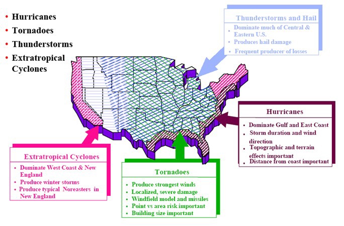
HazusWindHazards

What are the Capabilities of HAZUS-MH?

HAZUS-MH estimates physical damages to buildings and their contents, essential facilities, bridges, and pipelines. To break it down even further, HAZUS-MH can estimate direct and indirect losses (such as debris generation). Direct losses include cost of repairs or replacements, income loss, and agricultural losses. Indirect losses include supply shortages and sales declines.
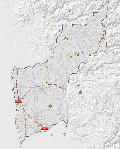
Example+HAZUS-MH+Output

Example of HAZUS-MH output list of schools from HAZUS-MH verse Yuba County GIS. Red denotes Hazus fire stations, yellow denotes volunteer and city fire departments, and blue denotes CDF facilities.

How does HAZUS estimate losses?

The estimation is calculated by spatial analysis methods using publicly-available databases (including Census 2000 and Dun & Bradstreet Data of commercial businesses) and nationally-standardized loss estimation and risk assessment methodology provided by the National Institute of Building Sciences (NIBS). These nationwide databases include demographics, building stocks, essential facilities, transportation, utilities, and high-potential loss facilities data.

What are the benefits of using HAZUS?

Knowing the relative values of potential losses has the sort of forecasting power that can distinguish one-hit wonders from superstars like The Beatles before their songs hit the radio waves. For practitioners and policymakers faced with decision-making during natural disasters this kind of valuation is priceless. Why? Earthquakes, floods, and hurricanes generate billions of dollars in losses. By knowing the potential losses, HAZUS-MH, enables users to:

  • Identify vulnerable areas that may require planning considerations.
  • Assess level of readiness and preparedness to deal with a disaster before it occurs.
  • Estimate potential losses from specific hazard events (before or after a disaster hits).
  • Decide how to allocate resources for most effective and efficient response and recovery.
  • Prioritize action plans that need to be implemented to reduce future losses.

The More Complicated Question

Answering the question, “How can we plan to minimize damage and loss of life to prevent natural hazards from becoming natural disasters?” is best compared to being one song within an entire album. In the blog “Forces of Nature: The Economic Impact of Natural Disasters” we ask the bigger question, “What results and trends can we expect when a natural disaster event occurs in a given region?” Seems simple enough right? The blog demonstrates that the answer to that question might be a little more complex than you’d expect. 

Why IMPLAN?

Put simply, IMPLAN is built for everyone.

Together, our software and data give you a window into your region of study — like one gigantic transaction log for the local economy. Chances are that if your project or business has a financial component, then IMPLAN can reveal some sometimes surprising detail about how your project relates to the local, state, or national economy.

What used to take economists weeks can be done in minutes. By anyone! But you're not alone, IMPLAN's best benefits go beyond the work done in the tool:

  • Instills confidence in your analyses
  • Easy to learn and use
  • Outstanding customer support
  • Access to orientations, trainings, and project consultations
Get a Demo
Want to
try it out?
Get a Demo
Ready to
dive in?
Request Pricing
Still have
questions?
Talk To An Expert
  • IMPLAN

    Economic input output modeling application, data, and solutions.


    IMPLAN © Copyright 2026

  • Contact

    8935 Northpointe Executive Park Drive
    Suite 125
    Huntersville, NC 28078

    (800) 507-9426

    support@implan.com

    Contact Us

    Media Inquiries

  • Reference

    Privacy Policy
    Website Terms of Service
    Citation Guidelines
    Security, Privacy and Compliance

  • Navigation

    Product
    Solutions
    Use Cases
    Resources
    Pricing
    Support
    Sign in
    Careers